
tropical-storm-erin-first-hurricane-2025 2025 Atlantic season. Read the latest Blog Draft: Tropical Storm Erin Could Become 2025 Tropical Storm Erin, moving west from Cabo Verde, could become the first hurricane of the 2025 Atlantic season. Read the latest forecast, risks, and preparedness tips.
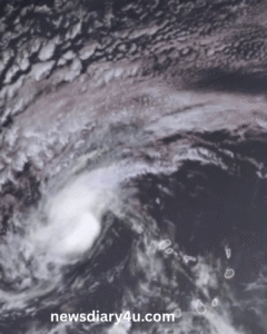
Tropical Storm Erin has officially formed in the eastern Atlantic, emerging near the Cape Verde Islands on August 11 as the fifth named storm of the 2025 Atlantic hurricane season. With sustained winds measuring roughly 45 mph and a steady westward pace near 20–23 mph, Erin is grabbing the attention of meteorologists—and rightly so
Why Erin Stands Out
Experts expect Erin to become the season’s first hurricane by midweek, potentially strengthening into a major Category 3 storm by the weekend This timing aligns with the historical average; the first hurricane usually forms around August 11
Several conditions favor Erin’s growth, including:
-
Warm sea-surface temperatures, rising from around 26 °C (79 °F) near its origin to 28–29 °C by midweek
Where Is Erin Headed?
Erin is tracking westward now, expected to shift toward west–northwest by midweek
-
Caribbean interest: Forecasts suggest it may slide north of the Leeward Islands, Virgin Islands, and Puerto Rico, but impacts including heavy surf and squalls remain possible
-
US East Coast and beyond: Models propose a northeastern turn between the U.S. coast and Bermuda, which might keep it offshore. Still, rough surf and rip currents could affect the Carolinas up through Maine
-
Bermuda & Atlantic Canada: These regions may face increased risk if Erin’s track bends northward later next week
Early Devastation: Cape Verde Impact
Before being named, the storm unleashed deadly flooding across Cape Verde. Particularly on São Vicente, heavy rains claimed 8 lives, prompting disaster declarations for both São Vicente and Santo Antão
What Erin Tells Us About the Season Ahead
NOAA had forecasted an above-normal 2025 season, projecting 13–19 named storms, with 6–10 becoming hurricanes and 3–5 turning major
Erin’s quick formation and forecasted intensification underscore this pattern. With increasing sea surface temperatures driven by climate change, storms now form earlier and strengthen faster—a concerning sign for communities across the Atlantic
Take Action: Preparing for Erin and Beyond
Even though Erin remains far from land, it’s wise for those in the Caribbean, U.S. East Coast, Bermuda, and Atlantic Canada to stay alert. Safety experts recommend:
-
Monitoring forecasts from the NHC and trusted regional weather sources
-
Developing evacuation plans and organizing emergency kits with essentials like water, non-perishable food, first aid supplies, and important documents
-
Reviewing insurance policies, ensuring they cover flood damage—awareness is key before a storm is named.
Closing Thoughts
Tropical Storm Erin is more than a typical early-season storm—it may set the tone for a potentially intense 2025 hurricane season. With conditions ripe for rapid intensification and a wide forecast cone, Erin calls for vigilance, preparedness, and clear eyes on evolving paths. Stay informed—this storm could be the first of many.
: Intentionally kept to a minimum to maintain a dynamic, engaging tone.
-
-